Search results
Search found 27 Ramsar Sites covering 5,144,804 ha
- (-) Remove Threats: Pollution filter Threats: Pollution
- (-) Remove Sites on Montreux record?: No filter Sites on Montreux record?: No
- (-) Remove Ecosystem services: Regulating Services filter Ecosystem services: Regulating Services
- (-) Remove Threats: Industrial and military effluents filter Threats: Industrial and military effluents
- (-) Remove Picture available?: Yes filter Picture available?: Yes
- (-) Remove Management plan available: In preparation filter Management plan available: In preparation
Map
Materials presented on this website, particularly maps and territorial information, are as-is and as-available based on available data and do not imply the expression of any opinion whatsoever on the part of the Secretariat of the Ramsar Convention concerning the legal status of any country, territory, city or area, or of its authorities, or concerning the delimitation of its frontiers or boundaries.
List
-
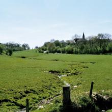


Vallée de la Haute-Sûre
-
Country:Luxembourg
-
Designation date:08-03-2004
-
Site number:1408
-
Published since:21 year(s)
16,900 ha -
-
 in spring")
Béda-Karapancsa
-
Country:Hungary
-
Designation date:30-04-1997
-
Site number:901
-
Published since:8 year(s)
8,669 ha -
-

Bodrogzug
-
Country:Hungary
-
Designation date:17-03-1989
-
Site number:422
-
Published since:7 year(s)
4,220 ha -
-

Lakes by Tata
-
Country:Hungary
-
Designation date:17-03-1989
-
Site number:419
-
Published since:7 year(s)
1,897 ha -
-


 observada en enero de 2005 descansando en los humedales de la Popotera durante su migración.")
 es la especie que permanece mayor tiempo asoleándose sobre los pantanos y puede observarse fácilmente.")
 es la especie de tortuga dulceacuícola en mayor peligro de extinción en México, y estos humedales representan uno de sus últimos refugios en el estado de Veracruz.")
Humedales de la Laguna La Popotera
-
Country:Mexico
-
Designation date:05-06-2005
-
Site number:1462
-
Published since:18 year(s)
1,975 ha -
-


Presa Manuel Ávila Camacho
-
Country:Mexico
-
Designation date:02-02-2012
-
Site number:2027
-
Published since:12 year(s)
23,612 ha -
-


Tianjin Beidagang Wetlands
-
Country:China
-
Designation date:03-02-2020
-
Site number:2425
-
Published since:3 year(s)
1,130 ha -
-


Kozyansky
-
Country:Belarus
-
Designation date:29-03-2013
-
Site number:2196
-
Published since:3 year(s)
28,469 ha -
-


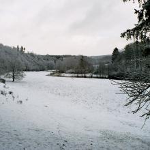
Dnipro-Oril Floodplains
-
Country:Ukraine
-
Designation date:17-11-2003
-
Site number:1399
-
Published since:2 year(s)
2,560 ha -
-

.")
.")


Burshtyn Water Reservoir
-
Country:Ukraine
-
Designation date:20-03-2019
-
Site number:2393
-
Published since:4 year(s)
1,260 ha -