Search results
Search found 22 Ramsar Sites covering 164,946 ha
- (-) Remove Region/country: Serbia filter Region/country: Serbia
- (-) Remove Region/country: Lithuania filter Region/country: Lithuania
- (-) Remove Region/country: Belarus filter Region/country: Belarus
- (-) Remove Region/country: Luxembourg filter Region/country: Luxembourg
- (-) Remove Management plan available: In preparation filter Management plan available: In preparation
- (-) Remove Region/country: Asia filter Region/country: Asia
- (-) Remove Region/country: Norway filter Region/country: Norway
- (-) Remove Region/country: Republic of Korea filter Region/country: Republic of Korea
Map
Materials presented on this website, particularly maps and territorial information, are as-is and as-available based on available data and do not imply the expression of any opinion whatsoever on the part of the Secretariat of the Ramsar Convention concerning the legal status of any country, territory, city or area, or of its authorities, or concerning the delimitation of its frontiers or boundaries.
List
-
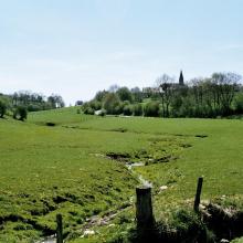


Vallée de la Haute-Sûre
-
Country:Luxembourg
-
Designation date:08-03-2004
-
Site number:1408
-
Published since:21 year(s)
16,900 ha -
-

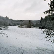
Zuvintas
-
Country:Lithuania
-
Designation date:04-10-1993
-
Site number:628
-
Published since:30 year(s)
7,500 ha -
-


Daebudo Tidal Flat
-
Country:Republic of Korea
-
Designation date:25-10-2018
-
Site number:2359
-
Published since:5 year(s)
453 ha -
-
Adutiskis-Svyla-Birveta wetland complex
-
Country:Lithuania
-
Designation date:15-11-2011
-
Site number:1992
-
Published since:12 year(s)
6,881 ha -
-


Dongcheon Estuary
-
Country:Republic of Korea
-
Designation date:20-01-2016
-
Site number:2269
-
Published since:7 year(s)
540 ha -
-


Hedmarksvidda Wetland System
-
Country:Norway
-
Designation date:12-11-2010
-
Site number:1951
-
Published since:0 year(s)
4,742 ha -
-


Kozyansky
-
Country:Belarus
-
Designation date:29-03-2013
-
Site number:2196
-
Published since:3 year(s)
28,469 ha -
-


Tufsingdeltaet
-
Country:Norway
-
Designation date:06-08-2002
-
Site number:1199
-
Published since:0 year(s)
895 ha -
-


Kvisleflået
-
Country:Norway
-
Designation date:06-08-2002
-
Site number:1193
-
Published since:0 year(s)
5,682 ha -
-


Isøyane
-
Country:Norway
-
Designation date:24-07-1985
-
Site number:316
-
Published since:0 year(s)
230 ha -