Search results

Map

Choose map: | | Download Centroids / Boundaries / Map (pdf)
Materials presented on this website, particularly maps and territorial information, are as-is and as-available based on available data and do not imply the expression of any opinion whatsoever on the part of the Secretariat of the Ramsar Convention concerning the legal status of any country, territory, city or area, or of its authorities, or concerning the delimitation of its frontiers or boundaries.

List

  1. Atnsjømyrene
    Atnsjømyrene

    Atnsjømyrene

    • Country: 
      Norway
    • Designation date: 
      12-11-2010
    • Site number: 
      1955
    • Published since: 
      0 year(s)
    533 ha
  2. Aerial view of Ulendeltaet
    Ulendeltaet
    Ulendeltaet
    Canoeing in lake Ulen
    Canoeing in lake Ulen

    Ulendeltaet

    • Country: 
      Norway
    • Designation date: 
      12-11-2010
    • Site number: 
      1967
    • Published since: 
      0 year(s)
    270 ha
  3. Birch forest and mire at Hynna
    Large mire area at Hynna
    MIre and stream at Hynna
    Mire area, the lake Nedre Reinsjøen in the background
    Early marsh-orchid at the mires.
    Open mire area east of the lake Vesle Reinsjøen.
    Mature spruce forest (here With healthy populations of the lichen Alectoria sarmentosa) are also found in the area.
    Hynna in the winter.
    Mire and lake area with cottongrass.

    Hynna

    • Country: 
      Norway
    • Designation date: 
      06-08-2002
    • Site number: 
      1191
    • Published since: 
      0 year(s)
    6,442 ha
  4. The islets and skerries found just outside Kalvøya.

    West-Vikna Archipelago

    • Country: 
      Norway
    • Designation date: 
      27-05-2013
    • Site number: 
      2165
    • Published since: 
      0 year(s)
    13,592 ha
  5. Laukvikøyene
    Laukvikøyene
    Laukvikøyene
    Laukvikøyene
    Laukvikøyene
    Laukvikøyene
    Laukvikøyene

    Laukvikøyene

    • Country: 
      Norway
    • Designation date: 
      27-05-2013
    • Site number: 
      2160
    • Published since: 
      0 year(s)
    1,084 ha
  6. Where the boats are moored
    Razorbill
    Razorbill
    Razorbill
    Anda lighthouse
    Anda lighthouse
    Anda lighthouse
    Anda lighthouse
    The path up to the lighthouse is between corridors of puffins nests in the ground
    Black-legged kittiwake
    Black-legged kittiwake and European shag
    Smaller kittiwake colony
    Use of cameras in the puffin nesting corridors
    Black-legged kittiwake
    Black-legged kittiwake
    Herring gull chick
    Common murre at nest site
    Black guillemot
    Atlantic puffin chick
    Atlantic puffin

    Anda

    • Country: 
      Norway
    • Designation date: 
      27-05-2013
    • Site number: 
      2155
    • Published since: 
      0 year(s)
    52 ha
  7. The bird cliff at Vårsolbukta
    Vårsolbukta
    Gravsjøen
    Kapp Martin
    Nordenskioldkysten in February
    Grønsteinodden at Nordenskioldkysten
    Migrating Northern fulmars at Revleodden in February
    Kapp Bjørset in February
    Marvågen with Protektorfjellet in the background

    Nordenskiöldkysten

    • Country: 
      Norway
    • Designation date: 
      12-11-2010
    • Site number: 
      1968
    • Published since: 
      0 year(s)
    42,992 ha
  8. Risøysundet
    Risøysundet
    Small bay in the Southwestern part of the Reserve. Risøybukta in the background.
    Small bay in the Southwestern part of the Reserve. Risøybukta in the background.
    Old road leading to Knutholmen. View towards the North.
    Old road leading to Knutholmen. Partly overgrown bunker.
    Old road leading to Knutholmen in Risøysundet.
    Wetland in Risøysundet
    Swans in Risøysundet
    View towards Northwestern parts of Risøysundet

    Risøysundet

    • Country: 
      Norway
    • Designation date: 
      27-05-2013
    • Site number: 
      2163
    • Published since: 
      0 year(s)
    504 ha
  9. Lower Songkram River
    Fish of Songkhram River
    Lower Songkram River
    Fish from Songkhram river at the local marketplace.
    Fish from Songkhram river at the local marketplace.
    Lower Songkram river.
    Lower Songkram river.
    Life of locals at the river.
    Life of locals at the river.
    Life of locals at the river.
    flooded forest of Songkram river.
    Lower Songkram river.

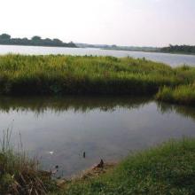
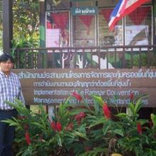
    Lower Songkhram River

    • Country: 
      Thailand
    • Designation date: 
      15-05-2019
    • Site number: 
      2420
    • Published since: 
      3 year(s)
    5,505 ha
  10. Nong Bong Kai Non-Hunting Area

    • Country: 
      Thailand
    • Designation date: 
      05-07-2001
    • Site number: 
      1101
    • Published since: 
      22 year(s)
    434 ha

Pages

Stats


Exports

Export Sites information

For a summary list of all the Ramsar Sites in pdf format, click here.

Generate reports of selected Sites

You can generate a report based on the filters you have applied, in either pdf or xls format. The report will sort the results by the Site name, unless you have sorted them by another variable.

For the pdfs, you can choose whether to include the introductory text on each Site, or just show the key data in a shorter report.

To receive a report, please provide your email address and enter the text in the verification picture into the textbox.

As soon as the list has been generated an e-mail will be sent to you with the link to access the file.