Search results
Search found 23 Ramsar Sites covering 1,556,975 ha
- (-) Remove Region/country: Serbia filter Region/country: Serbia
- (-) Remove Threats: Biological resource use filter Threats: Biological resource use
- (-) Remove Region/country: Spain filter Region/country: Spain
- (-) Remove Region/country: Denmark filter Region/country: Denmark
- (-) Remove Region/country: Greece filter Region/country: Greece
- (-) Remove Ramsar criteria: 4 filter Ramsar criteria: 4
- (-) Remove Picture available?: Yes filter Picture available?: Yes
- (-) Remove Region/country: Germany filter Region/country: Germany
Map
Materials presented on this website, particularly maps and territorial information, are as-is and as-available based on available data and do not imply the expression of any opinion whatsoever on the part of the Secretariat of the Ramsar Convention concerning the legal status of any country, territory, city or area, or of its authorities, or concerning the delimitation of its frontiers or boundaries.
List
-

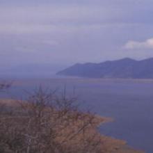


Lake Mikri Prespa
-
Country:Greece
-
Designation date:21-08-1975
-
Site number:60
-
Published since:26 year(s)
5,078 ha -
-


Ismaninger water reservoir with fish ponds
-
Country:Germany
-
Designation date:26-02-1976
-
Site number:92
-
Published since:0 year(s)
986 ha -
-


Lake Ammer
-
Country:Germany
-
Designation date:26-02-1976
-
Site number:93
-
Published since:0 year(s)
6,386 ha -
-


Lake Chiemsee
-
Country:Germany
-
Designation date:26-02-1976
-
Site number:95
-
Published since:0 year(s)
8,231 ha -
-

Lake Galenbeck
-
Country:Germany
-
Designation date:31-07-1978
-
Site number:177
-
Published since:0 year(s)
1,040 ha -
-


Doñana
-
Country:Spain
-
Designation date:04-05-1982
-
Site number:234
-
Published since:17 year(s)
111,646 ha -
-


Aqajarua, Qaamassoq and Sullorsuaq
-
Country:Denmark (Greenland)
-
Designation date:27-01-1988
-
Site number:381
-
Published since:4 year(s)
26,440 ha -
-


Kuannersuit Kuussuat
-
Country:Denmark (Greenland)
-
Designation date:27-01-1988
-
Site number:383
-
Published since:4 year(s)
3,800 ha -
-


Kitsissunnguit
-
Country:Denmark (Greenland)
-
Designation date:27-01-1988
-
Site number:384
-
Published since:4 year(s)
6,910 ha -
-


Naternaq
-
Country:Denmark (Greenland)
-
Designation date:27-01-1988
-
Site number:385
-
Published since:4 year(s)
191,000 ha -