Search results
Search found 299 Ramsar Sites covering 5,956,351 ha
- (-) Remove Region/country: Europe filter Region/country: Europe
- (-) Remove Picture available?: Yes filter Picture available?: Yes
- (-) Remove Threats: Invasive and other problematic species and genes filter Threats: Invasive and other problematic species and genes
Map
Materials presented on this website, particularly maps and territorial information, are as-is and as-available based on available data and do not imply the expression of any opinion whatsoever on the part of the Secretariat of the Ramsar Convention concerning the legal status of any country, territory, city or area, or of its authorities, or concerning the delimitation of its frontiers or boundaries.
List
-

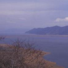


Lake Mikri Prespa
-
Country:Greece
-
Designation date:21-08-1975
-
Site number:60
-
Published since:26 year(s)
5,078 ha -
-


Trappola Marshland - Ombrone River Mouth
-
Country:Italy
-
Designation date:13-10-2016
-
Site number:2284
-
Published since:7 year(s)
536 ha -
-


Hornborgasjön
-
Country:Sweden
-
Designation date:05-12-1974
-
Site number:22
-
Published since:7 year(s)
6,197 ha -
-

Hjälstaviken
-
Country:Sweden
-
Designation date:05-12-1974
-
Site number:25
-
Published since:7 year(s)
808 ha -
-

.")

Övre Sulån
-
Country:Sweden
-
Designation date:14-11-2001
-
Site number:1130
-
Published since:7 year(s)
350 ha -
-


Kaltbrunner Riet
-
Country:Switzerland
-
Designation date:09-11-1990
-
Site number:509
-
Published since:7 year(s)
157 ha -
-


Northern Part of the Dniester Liman
-
Country:Ukraine
-
Designation date:28-02-1997
-
Site number:765
-
Published since:1 year(s)
25,929 ha -
-


Archipelago Velyki and Mali Kuchugury
-
Country:Ukraine
-
Designation date:24-12-2013
-
Site number:2282
-
Published since:7 year(s)
7,740 ha -
-


Byle Lake and Koza Berezyna Mire
-
Country:Ukraine
-
Designation date:24-12-2013
-
Site number:2281
-
Published since:7 year(s)
8,036 ha -
-


Kryva Bay and Kryva Spit
-
Country:Ukraine
-
Designation date:28-02-1997
-
Site number:774
-
Published since:1 year(s)
11,861 ha -