
Salburua
- Country:Spain
- Site number:1263
- Area:174 ha
- Designation date:24-10-2002
- Coordinates:42°51'N 02°39'W
Materials presented on this website, particularly maps and territorial information, are as-is and as-available based on available data and do not imply the expression of any opinion whatsoever on the part of the Secretariat of the Ramsar Convention concerning the legal status of any country, territory, city or area, or of its authorities, or concerning the delimitation of its frontiers or boundaries.
Overview
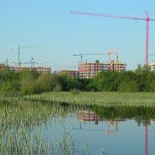
Salburua. 24/10/02; País Vasco; 174 ha; 42°51'N 002°39'W. A complex of two shallow lakes at the edge of Vitoria-Gasteiz, the capital of the Basque autonomous region (220,000 inhabitants). The marshes were drained during the 20th century and subsequently restored in the 1990s. Arkaute lake fulfils a key hydrological function in preventing flooding of the nearby part of town. The site contains the most extensive Carex riparia reedbed of the Iberian peninsula and other priority habitats of the EC Habitats Directive. The population of the globally endangered European mink Mustela lutreola is noteworthy. The area is used for research and environmental education. Specific trails and picnic areas are designated for nature tourists. Controlled grazing with a herd of deer is managing the emergent aquatic vegetation. Ramsar site no. 1263. Most recent RIS information: 2002.
Administrative region:
País Vasco
- Regional (international) legal designations:
- EU Natura 2000
- Last publication date:24-10-2002
Downloads
Ramsar Information Sheet (RIS)
Site map
Additional reports and documents
- A description of the site in a national or regional wetland inventory