
Salburua
- País:España
- Número del sitio:1263
- Superficie:174 ha
- Fecha de designación:24-10-2002
- Coordenadas:42°51'N 02°39'W
Los materiales presentados en este sitio web, particularmente los mapas y la información territorial, se proporcionan tal cual y según están disponibles a partir de los datos de los que se dispone y no implican la expresión de opinión alguna por parte de la Secretaría de la Convención de Ramsar respecto de la condición jurídica de ningún país, territorio, ciudad o zona, ni de sus autoridades, ni respecto de la delimitación de sus límites o fronteras.
Resumen
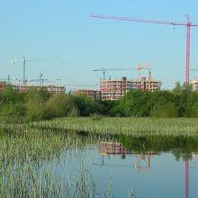
Salburua. 24/10/02; País Vasco; 174 ha; 42°51'N 002°39'W. A complex of two shallow lakes at the edge of Vitoria-Gasteiz, the capital of the Basque autonomous region (220,000 inhabitants). The marshes were drained during the 20th century and subsequently restored in the 1990s. Arkaute lake fulfils a key hydrological function in preventing flooding of the nearby part of town. The site contains the most extensive Carex riparia reedbed of the Iberian peninsula and other priority habitats of the EC Habitats Directive. The population of the globally endangered European mink Mustela lutreola is noteworthy. The area is used for research and environmental education. Specific trails and picnic areas are designated for nature tourists. Controlled grazing with a herd of deer is managing the emergent aquatic vegetation. Ramsar site no. 1263. Most recent RIS information: 2002.
Región administrativa:
País Vasco
- Designaciones jurídicas regionales (internacionales):
- Natura 2000 (Unión Europea)
- Fecha de última publicación:24-10-2002
Descargas
Ficha Informativa de los Humedales de Ramsar (FIR)
Mapa del sitio
Informes y documentos adicionales
- Una descripción del sitio en un inventario nacional o regional de los humedales