Search results
Search found 142 Ramsar Sites covering 22,398,773 ha
- (-) Remove Wetland type: Inland wetlands filter Wetland type: Inland wetlands
- (-) Remove Wetland type: Human-made wetlands filter Wetland type: Human-made wetlands
- (-) Remove Wetland type: Sp: Permanent saline/ brackish/ alkaline marshes/ pools filter Wetland type: Sp: Permanent saline/ brackish/ alkaline marshes/ pools
- (-) Remove Threats: Biological resource use filter Threats: Biological resource use
- (-) Remove Sites on Montreux record?: No filter Sites on Montreux record?: No
- (-) Remove Wetland type: 6: Water storage areas/Reservoirs filter Wetland type: 6: Water storage areas/Reservoirs
- (-) Remove Picture available?: Yes filter Picture available?: Yes
Map
Materials presented on this website, particularly maps and territorial information, are as-is and as-available based on available data and do not imply the expression of any opinion whatsoever on the part of the Secretariat of the Ramsar Convention concerning the legal status of any country, territory, city or area, or of its authorities, or concerning the delimitation of its frontiers or boundaries.
List
-
 congregating in shallow areas of the lagoon in Ría Celestún, one of their main resting and feeding habitats in the Yucatan Peninsula. Boats approach the flamingos to a certain extent in order not to scare them away.")
.")

 amidst the mangrove, due to the presence of a freshwater spring typically called \"ojo de agua\".")

Reserva de la Biosfera Ría Celestún
-
Country:Mexico
-
Designation date:02-02-2004
-
Site number:1333
-
Published since:20 year(s)
81,482 ha -
-


Sim Maiakiv Floodplain
-
Country:Ukraine
-
Designation date:24-12-2013
-
Site number:2273
-
Published since:7 year(s)
2,140 ha -
-


Bassin du Nakanbé-Mané
-
Country:Burkina Faso
-
Designation date:02-02-2016
-
Site number:2254
-
Published since:8 year(s)
19,477 ha -
-

Lac Boulhilet
-
Country:Algeria
-
Designation date:18-12-2009
-
Site number:1897
-
Published since:6 year(s)
856 ha -
-


Barrage de Yalgo
-
Country:Burkina Faso
-
Designation date:02-02-2016
-
Site number:2258
-
Published since:8 year(s)
4,522 ha -
-


Shagany-Alibei-Burnas Lakes System
-
Country:Ukraine
-
Designation date:28-02-1997
-
Site number:763
-
Published since:2 year(s)
27,600 ha -
-


Tendrivska Bay
-
Country:Ukraine
-
Designation date:28-02-1997
-
Site number:768
-
Published since:1 year(s)
55,022 ha -
-
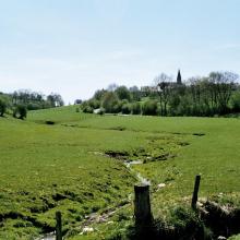

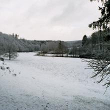

Vallée de la Haute-Sûre
-
Country:Luxembourg
-
Designation date:08-03-2004
-
Site number:1408
-
Published since:21 year(s)
16,900 ha -
-


 au bord du lac")


")
Lac Dem
-
Country:Burkina Faso
-
Designation date:07-10-2009
-
Site number:1882
-
Published since:7 year(s)
1,354 ha -
-


Les Rapides du Congo-Djoué
-
Country:Congo
-
Designation date:03-04-2009
-
Site number:1857
-
Published since:15 year(s)
2,500 ha -