Search results
Search found 275 Ramsar Sites covering 14,146,033 ha
- (-) Remove Wetland type: Inland wetlands filter Wetland type: Inland wetlands
- (-) Remove Wetland type: U: Permanent Non-forested peatlands filter Wetland type: U: Permanent Non-forested peatlands
- (-) Remove Wetland type: Zg: Geothermal wetlands filter Wetland type: Zg: Geothermal wetlands
- (-) Remove Picture available?: Yes filter Picture available?: Yes
Map
Materials presented on this website, particularly maps and territorial information, are as-is and as-available based on available data and do not imply the expression of any opinion whatsoever on the part of the Secretariat of the Ramsar Convention concerning the legal status of any country, territory, city or area, or of its authorities, or concerning the delimitation of its frontiers or boundaries.
List
-


Tourbière de Moltifao
-
Country:France
-
Designation date:27-10-2011
-
Site number:1994
-
Published since:0 year(s)
34 ha -
-


Tourbière du Lac Noir
-
Country:Algeria
-
Designation date:06-04-2003
-
Site number:1305
-
Published since:5 year(s)
5 ha -
-


")


")


Tourbières et lacs de la Montagne jurassienne
-
Country:France
-
Designation date:02-02-2003
-
Site number:1266
-
Published since:3 year(s)
12,156 ha -
-


Tufsingdeltaet
-
Country:Norway
-
Designation date:06-08-2002
-
Site number:1199
-
Published since:1 year(s)
895 ha -
-


Turiec wetlands
-
Country:Slovakia
-
Designation date:17-02-1998
-
Site number:932
-
Published since:17 year(s)
750 ha -
-


Tysjöarna
-
Country:Sweden
-
Designation date:14-11-2001
-
Site number:1132
-
Published since:7 year(s)
424 ha -
-


Ulendeltaet
-
Country:Norway
-
Designation date:12-11-2010
-
Site number:1967
-
Published since:1 year(s)
270 ha -
-
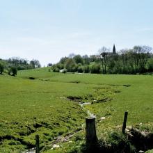


Vallée de la Haute-Sûre
-
Country:Luxembourg
-
Designation date:08-03-2004
-
Site number:1408
-
Published since:21 year(s)
16,900 ha -
-


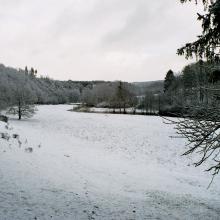
Vallée de la Haute-Sûre
-
Country:Belgium
-
Designation date:08-03-2004
-
Site number:1407
-
Published since:8 year(s)
29,000 ha -
-


Vallées de la Scarpe et de l'Escaut
-
Country:France
-
Designation date:02-02-2020
-
Site number:2405
-
Published since:4 year(s)
27,622 ha -