Search results
Map
Materials presented on this website, particularly maps and territorial information, are as-is and as-available based on available data and do not imply the expression of any opinion whatsoever on the part of the Secretariat of the Ramsar Convention concerning the legal status of any country, territory, city or area, or of its authorities, or concerning the delimitation of its frontiers or boundaries.
List
-


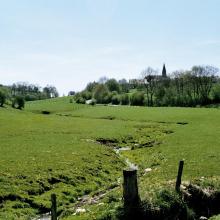
Vallée de la Haute-Sûre
-
Country:Belgium
-
Designation date:08-03-2004
-
Site number:1407
-
Published since:9 year(s)
29,000 ha -
-

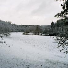

Vallée de la Haute-Sûre
-
Country:Luxembourg
-
Designation date:08-03-2004
-
Site number:1408
-
Published since:21 year(s)
16,900 ha -
-

Csongrád-Bokrosi Sóstó sodic-alkaline pans
-
Country:Hungary
-
Designation date:04-12-2004
-
Site number:1409
-
Published since:8 year(s)
865 ha -
-

Upper Tisza (Felsö-Tisza)
-
Country:Hungary
-
Designation date:10-01-2004
-
Site number:1410
-
Published since:7 year(s)
26,871 ha -
-
Tisa River
-
Country:Slovakia
-
Designation date:04-12-2004
-
Site number:1411
-
Published since:19 year(s)
735 ha -
-

Lake Lanoto'o
-
Country:Samoa
-
Designation date:10-07-2004
-
Site number:1412
-
Published since:12 year(s)
470 ha -
-
Punkva subterranean stream
-
Country:Czechia
-
Designation date:18-03-2004
-
Site number:1413
-
Published since:20 year(s)
1,571 ha -
-


Chott Aïn El Beïda
-
Country:Algeria
-
Designation date:12-12-2004
-
Site number:1414
-
Published since:5 year(s)
6,853 ha -
-


Chott El Beïdha-Hammam Essoukhna
-
Country:Algeria
-
Designation date:12-12-2004
-
Site number:1415
-
Published since:5 year(s)
12,223 ha -
-


Chott Oum El Raneb
-
Country:Algeria
-
Designation date:12-12-2004
-
Site number:1416
-
Published since:6 year(s)
7,155 ha -