Côte Aftissate-Boujdour
Côte Aftissate-Boujdour
- Country:
- Morocco
- Site number:
- 2377
- Area:
- 11,700.0 ha
- Designation date:
- 16-04-2019
- Coordinates:
- 25°48'10"N 14°35'59"W
Carousel
Carousel
")
")


Materials presented on this website, particularly maps and territorial information, are as-is and as-available based on available data and do not imply the expression of any opinion whatsoever on the part of the Secretariat of the Ramsar Convention concerning the legal status of any country, territory, city or area, or of its authorities, or concerning the delimitation of its frontiers or boundaries.
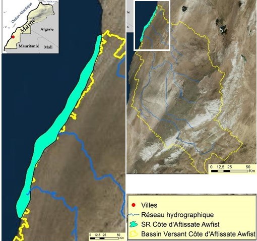
The Site covers some 50 kilometres of coastline to the south of the town of Boujdour. A 70-metre-high sea cliff overlooks a continuous low-lying furrow separated from the ocean by a beach and mobile dunes. It is at the southern limit of the Palearctic ecozone, while coastal upwelling shapes its hydrological and sedimentary dynamics, its productivity and its climate. The wetland provides a stopover point for Palearctic seabirds, waders and land migrants, especially passerines. In winter, species such as the lesser black-backed gull (Larus fuscus) are present in populations greater than 1% of their biogeographic populations. The dry areas of the Site, strongly influenced by the ocean, are home to several endemic and rare species such as the endemic gecko Saurodactylus brosseti. The Site features relatively densely-vegetated steppes featuring endemic or rare plant species including Anacyclus maroccanus, Bupleurum dumosum and Pallenis teknensis. The Site’s marine resources provide sustainable income for the local communities; conservation measures are proposed to minimize the potential threats and also to ensure local livelihoods.
- MA2377RIS_1907_fr.pdf
- MA2377_map181208.jpg